ArcheoFOSS 2022
From the Itinerarium Antonini and al-Idrisi to the movecost plug-in: study of the viability in the Castronovo di Sicilia area by comparing traditional sources and least-cost path analysis
Gabriele Ciccone
Dipartimento di Storia, Patrimonio Culturale, Formazione e Società. Università di Roma Tor Vergata, Rome, Italy
Panel: Moving in the past: open solutions for data set design, spatial analysis and geo-statistical methods to investigate movement in Antiquity
The area of Castronovo di Sicilia, focus of the ERC Sictransit project and of the PhD project Flying off-site: new methodologies for the analysis of historical landscapes, was analyzed by integrating different methodologies. About the viability of the area it was decided to compare what is known, through the traditional written sources obtained from the Itinerarium Antonini and from the texts of the Arab geographer al-Idrisi,vectorized on map by Stangati (2010, 2013, 2014), with the results of the Least-Cost Path Analysis (LCPA) carried out through the QGIS plug-in movecost, using the well known on-path Tobler’s hiking function. The analysis of traditional sources highlighted the centrality of Castronovo in ancient times, both along the main N-S route, which connected Palermo to Agrigento since Roman times (VIII-Item ab Agrigento Lilybeo in the Itinerarium Antonini), and along the E-W route, which connected the coasts of the island through one of the main transhumance routes, probably used since the protohistoric era (Via dei Jenchi). The texts of al-Idrisi, in the same way, highlight how the centrality of the Castronovo area was still a determining factor in the Arab-Norman phase. Commissioned by Roger II to write a text that included the entire geographical knowledge of the time, al-Idrisi published in Palermo, in 1154, the book better known as The Book of Roger. In the work, in the Fourth Climate-Second Compartment-The Islands, al-Idrisi provides a description of Sicily, in which the town of Castronovo is mentioned several times with distances that separated it from other centers of the Arab-Norman phase.
Starting from these data, the LCP analysis was subsequently developed. The analysis was carried out on both at a regional and a local scale,using as principal source the DTM (30-90m) automatically downloaded by the plugin from the NASA SRTM server.
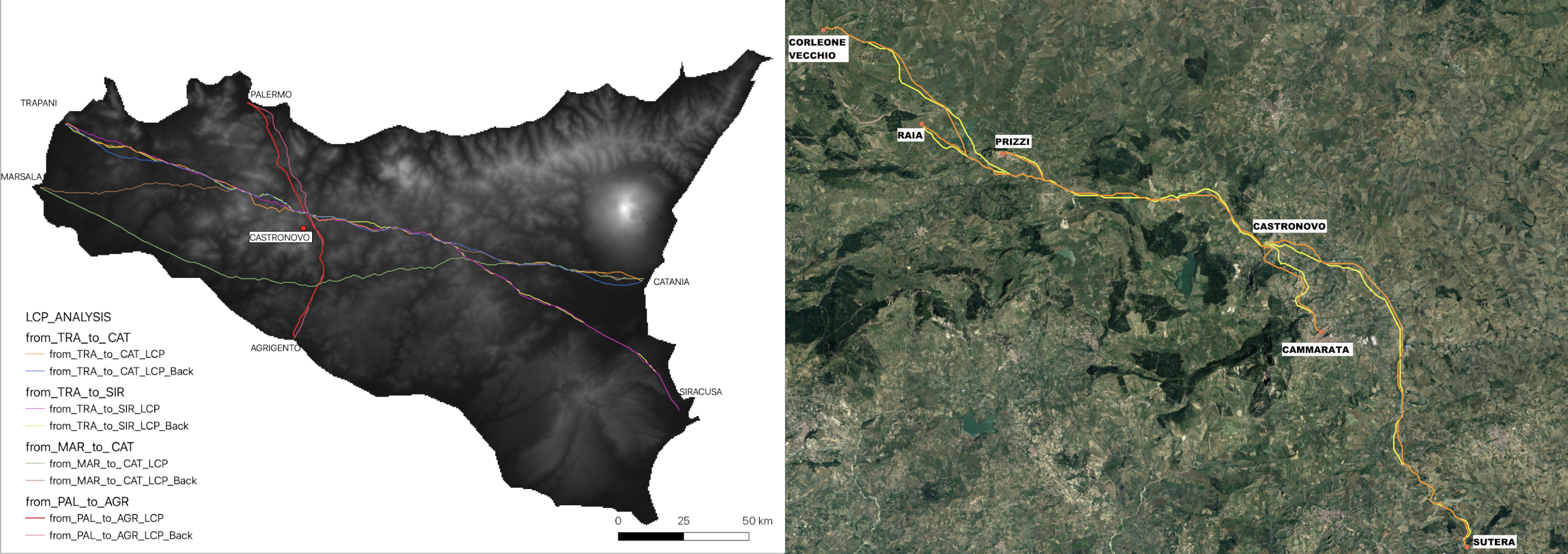
As regards the regional analysis, Palermo and Agrigento, for the N-S route and Trapani, Marsala, Catania and Syracuse, for the E-W route were therefore used as departure and arrival points. The main objective of this analysis was to evaluate how the centrality of the Castronovo area was also determined by an environmental factor that naturally made it an easily accessible place along the main long-distance routes that connected the island. In the same way we wanted to highlight how much correspondence there was between the main itineraries of the classical age and the results of the LCP analysis.
The next phase focused instead on a local scale, to compare the distances mentioned by al-Idrisi between Castronovo and Cammarata, Prizzi, Corleone, Raia and Sutera. The results showed an excellent correspondence between some distances expressed by al-Idrisi and the respective LCP results along the E-W route, while the distances expressed by the Arab geographer between Castronovo and the centers located to the south are much less precise. In this case, the results of the LCP, together with other clues in al-Idrisi’s book, seem to confirm that the Arab geographer had direct knowledge of Castronovo, Prizzi and Corleone (probably from a journey he actually took) and only indirectly of the other places.
License
- The text is release under CC BY 4.0 International license. Copyright by Gabriele Ciccone 2022
- The image is released under CC BY-ND 4.0 International license. Copyright by Gabriele Ciccone 2022