ArcheoFOSS 2020
Analysis of urban mobility in 18th century Rome: a research approach through GIS platform
Domizia D’Erasmo
https://uniroma1.academia.edu/DomiziaDErasmo
Graduated in 2017 at Sapienza University of Rome in Archaeological Sciences, Domizia D’Erasmo combines an Egyptological background with skills in Digital Humanities, acquired during her university career. In January 2020 she won a Sapienza Junior Research Grant aimed at the development of a GIS platform to investigate the urban mobility of eighteenth-century Rome. Her recent scientific interests combine the study of the ancient Egyptian landscape with Digital Humanities. She is also a tutor for the QGIS workshops directed by Julian Bogdani in the framework of the ERC PAThs project (P.I. Paola Buzi).
Renata Ago
https://iris.uniroma1.it/browse?type=author&authority=rp43582
Renata Ago former Full Professor, now Honorary Professor at Sapienza University of Rome where she taught Early modern history. She has been fellow or visiting professor in several institutions and member of the editorial board of different academic journals. In 2009-2014 she was the general scientific coordinator of the European project “European Network for Baroque Cultural Heritage”. Her scientific interests concern social history in early modern times. She has worked on rural communities and feudality from the 16th to the 18th centuries, on family and gender history and on the relationship between social exchanges, economic practices and institutions. Her recent interests regard issues on consumption and material culture.
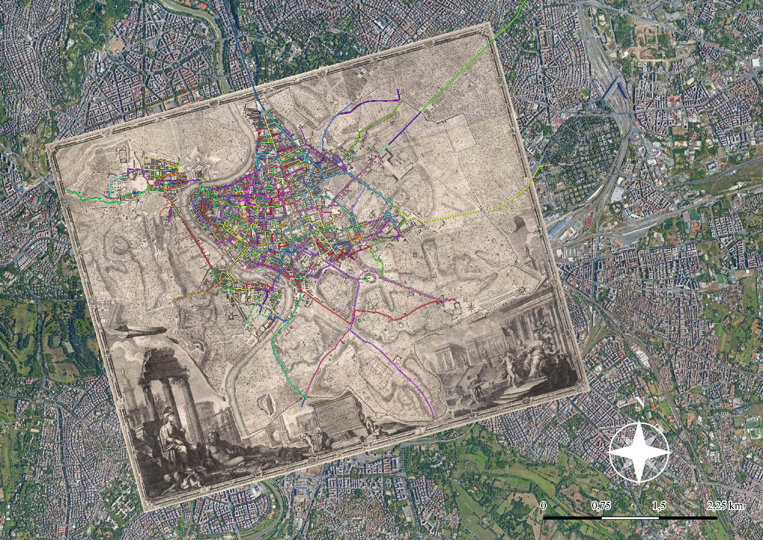
The aim of this paper is to describe the methodology employed for the development of a GIS platform capable of analysing urban mobility in early-modern age. In order to increase the dissemination of data, QGIS is the software used in this research. The use of this tool has allowed not only the intercommunication between different operating systems (OS), but also the production of open source data. The research focuses on the case study of the pathways which took place inside and in the surroundings of the city walls of Rome in the 18th century. The town in this period appeared with an urban layout that was the result of a series of important initiatives by the authorities, especially the popes. As a result of these transformations, the increase of regular roads and “straight streets” is evident, as well as the adjustment of town squares and buildings. During the planning of the GIS project, this urban layout, which for the most part is no longer visible from modern satellite images, was recreated by using a georeferenced version of the Nuova Topografia di Roma by Giovanbattista Nolli: a city map that was published by the geometer in 1748, and which faithfully represents the urban landscape of eighteenth-century Rome.
Initially, several official itineraries such as papal parades, solemn entrances of ambassadors or foreign princes were mapped out. These paths were traced having access to accurate topographical information obtained from the analysis of booklets published on the occasion of particular events. In a second time we have mapped the common and ordinary daily movements of men and women, workers and shop masters (fig. 1). The itineraries of these “normal” people show a completely different picture from that obtained from the examination of the high-codified pathways. In fact, the reasons for these journeys mostly concern work or social occasions (fig. 2), such as visits to taverns. In order to collect the topographical information related to this kind of events, we have used a wide sample of judicial sources (trials and claims of the Tribunale criminale del Governatore) as well as of requests forwarded to the Presidenza delle Strade. In this phase the topographic data are less detailed than the previous ones and are mostly limited to a departure point and an arrival point, and in some cases to intermediate stops.
The vector data collected during the entire project were then queried in QGIS by spatial analysis aimed at detecting the main routes of urban movement in early-modern period. It emerged that the “new” roads built in the 18th century were rarely used, even in the context of codified pathways such as processions. In fact, the choice of roads appears to be attributable to factors in which the comfort of the streets is not the conditio sine qua non. In conclusion, the project in its entirety highlights the potentialities to analyse the topographical data obtained from the study of the textual sources by comparing them with those present in historical cartography through the GIS platform. Through this approach, it was possible to obtain a complete overview of the urban movements in 18th century Rome in relation to the new city building developments that have taken place in the town (fig. 3). Furthermore, this approach made it possible to query the data in order to extract information leading to an improved understanding of the uses of an ancient urban layout of this city.